BYER SANDSTONE
The Byer Sandstone Member (lower Logan Formation,
Waverly Group) is a brown sandstone-dominated unit with occasional shale and
mudrock partings. Some bedding planes in the Byer are covered with molds
of marine fossils, typically crinoid stem columnals and brachiopod
shells. Many of the fossil molds have limonite coatings.
The Kinderhookian Stage-Osagean Stage boundary is
usually considered to occur somewhere within the Byer Sandstone, but recent
regional correlations have indicated that the Byer is early Osagean in age
(late Early Mississippian). The Kinderhookian-Osagean boundary appears to
coincide with the disconformity at the base of the Logan Formation.
For a recent study on the Byer Sandstone and its
fossil biota, see:
Konfal, S. 2003. A Paleontological
Synthesis of the Lower Mississippian Byer Sandstone (Logan Formation) of Ohio.
Senior Thesis. Denison University. Granville, Ohio, USA. 122
pp.
State Farm Quarry
The State Farm Quarry is a small, abandoned,
one-project sandstone quarry located on a forested hillside in the western part
of Newark, Ohio. Dug out in the 1920s, the quarry provided building
stone-grade sandstone for use in construction of the Granville Inn in nearby
Granville, Ohio.
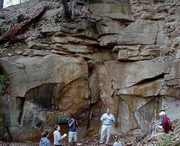
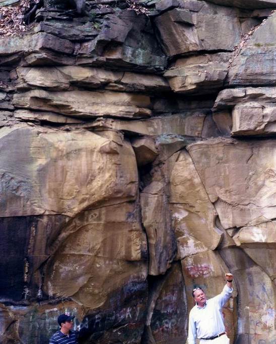
The sandstones exposed in the quarry are part of the
lower Byer Sandstone. Thin-bedded sandstones are present at the top of
the quarry and a thick, massive-weathering sandstone unit occurs below.
The lower sandstone interval is the only unit here suitable as building
stone. In the 19th century, several small quarries exposing this interval
were publicly accessible in the Granville area, leading to the early term
"freestone" for this unit.
Two obvious fossiliferous horizons are present near
the floor of the State Farm Quarry. Graffiti and “Leisgang Banding”
partly obscure the bedding characteristics of the sandstone here.
Location: abandoned hillside quarry behind State Farm
Insurance Building, north side of Granville Road, western side of Newark,
central Licking County, central Ohio, USA.
Some info. provided by Dan Leavell.
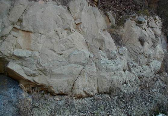
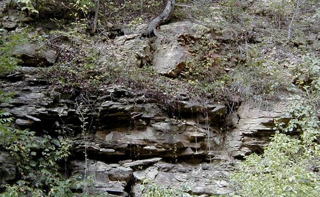
Dugway Outcrop
The Dugway is a moderately
large roadcut on the north side of Rt. 16 on the western side of Newark,
central Licking County, Ohio. From the base upward, it exposes the
Raccoon Shale, an unnamed sandstone-dominated interval, the Berne Conglomerate,
and the lower Byer Sandstone.
The only significant fossils
at the Dugway Outcrop are found in orangish brown-weathering quartzose
sandstones of the lower Byer Sandstone, representing a shallow marine
biota. Byer fossils here are principally brachiopods, crinoid stems, and
bivalves, preserved as molds (often limonitic).
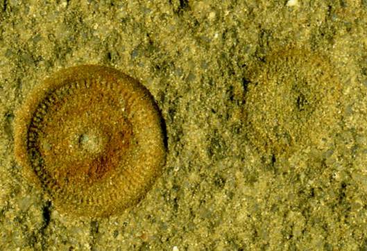
Larger columnal is ~8 mm in diameter.
Above & below: individual crinoid stem
columnals in quartzose sandstone. Fossiliferous bedding planes in the
Byer Sandstone typically have sparsely scattered to densely concentrated
crinoid columnals such as these.
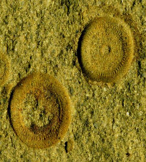
Each columnal is ~8 mm in
diameter.
Denison University Parking
Garage Cut
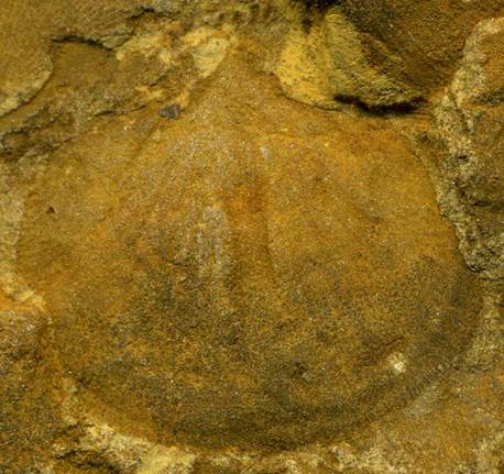
Shell is ~2.5 cm across at
its widest.
Interior surface of a Rhipidomella
brachiopod shell.
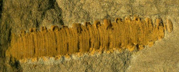
Preserved stem is 3.9 cm
long.
Crinoid stem material is abundant in the Byer
Sandstone, usually preserved as disarticulated individual columnals.
Above is a partial articulated crinoid stem. Crinoid stem material is
generally not identifiable to genus. Note that the stem shown above has
thick & thin columnals. The larger, thicker columnals are nodals.
The smaller, thinner columnals are internodals.
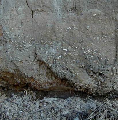
Lloyds Bridge Rd. roadcut
North of Jackson, Ohio, a
roadcut along Rt. 35 exposes the Mississippian-Pennsylvanian
unconformity. The cut is mostly sandstone, pebbly sandstone, and some
quartz-pebble conglomerate, a basal shale, and some channelforms. The basal
shale is part of the Cuyahoga Formation, unconformably separated from
sandstones and pebbly sandstones of the overlying Logan Formation. The
Mississippian-Pennsylvanian unconformity is about half-way to two-thirds of the
way from the base of the cut. Sandstones, pebbly sandstones, and
quartz-pebble conglomerates of the Sharon Formation (basal Pottsville Group,
Morrowan, upper Lower Pennsylvanian) occur above the Miss.-Penn. unconformity
here.
Sharon Formation (ss, congl.)
---------------------------------------------- Miss.-Penn. unc.
Logan Formation (ss, pebbly ss)
---------------------------------------------- unc.
Cuyahoga Formation (sh)
Above & below: lower
Logan Formation sandstone & pebbly sandstone (= Berne Member) unconformably
overlying gray shales of the Cuyahoga Formation. The Cuyahoga & Logan
here are Lower Mississippian.
Location: roadcut along the eastern
side of Rt. 35, immediately south of intersection with Lloyds Bridge Road, east
of Pine Ridge, north of Jackson, northeastern Liberty Township, central Jackson
County, southern Ohio, USA. GPS of cut: 39° 6.185' North, 82°
40.272' West.
Toboso Railroad Cut
The Logan Formation is
generally considered to consist of four members: a thin basal conglomerate
(Berne Member), the Byer Sandstone Member, another thin conglomeratic unit
(Allenville Member), and a Vinton Member. The Vinton Member typically
ranges from quartzose siltstones to fine-grained quartzose sandstones with some
fossiliferous horizons. Reported fossils are mostly small to medium-sized
brachiopods.
The photo below shows a
railroad cut a little east of Toboso, Ohio (= Black Hand Gorge area) that
exposes the Vinton Member of the upper Logan Formation. The Vinton
dates to the Osagean (upper Lower Mississippian).
Location: exposure along northern
side of railroad tracks, 0.15-0.2 miles west of Pleasant Valley Road & ~1.2
miles east of Toboso, eastern margin of Hanover Township, eastern margin of
Licking County (~0.05 miles west of Licking-Muskingum County line),
east-central Ohio, USA. Approximately 40° 03' 18" North, 82° 11'
38" West.